View the map.
Route 5 is about 17 km long (including a 1.5 km secondary route to Skiadi, one of the most impressive sights on Kimolos) and can be enjoyed as an all-day hike lasting 7-8 hours, including time to stop and rest.
Of the 14 km of the main road, 3.5 km are paved and 10.5 km are a passable dirt road with little traffic. You can do the route by car over most of its length, only taking the trail to Skiadi on foot. Either way, if you cross over from Milos just for the day, you must think ahead to your return and check the schedule of the little ferry in advance.
According to myth, the island was named after its first settler, Kimolos, wife of Side, the daughter of Taurus from Pamphylia in Asia Minor. It was also known by the name Echinousa, while during the period of Frankish rule it was called Argentiera (arzento = silver), because of the white gleam reflected by the island’s rocks in the Aegean light, or, in another version, because of the old mines of silver-bearing lead ores that are supposed to have existed on its north coast.
The first traces of habitation date to the Late Neolithic period. In the early first millennium BC, Dorians, probably from Laconia, who also colonized neighboring Milos, settled here. Archaeological finds from the sunken settlement located on the west side of the island at Ellinika testify to the continuous presence of people during the Mycenaean, Geometric and Archaic periods, into the Hellenistic period and the early Christian era.
In the 4th century BC, the Kimolians entered into a dispute with the Melians in regard to sovereignty over Polyaegos and the neighboring islets, which ended with a judgment by the Congress of the Greeks, with arbitration by the Argives, in favor of Kimolos. The exploitation and trading of Kimolian earth (used for medicinal purposes, for bleaching, as a detergent and in other ways), as well as the trade in figs, brought considerable wealth to the island, which from the 3rd century BC minted its own coins.
As in most of the Cyclades, after the period of Roman (Province of the Aegean) and Byzantine domination (Province of the Aegean Islands), came the Frankish (Duchy of the Aegean) and Ottoman periods, during which the island, like Milos, suffered much pillaging from pirate raids. Kimolos became part of the Greek state in 1830, along with the rest of the Cyclades.
Arriving by boat at Kimolos’ port at Psathi, you will notice on your left (on the western arm of the harbor) rhyolitic outcrops and lava flows, while on your right you will see tuffs containing fragments of pumice and lava in a jumbled, chaotic structure.
If you’re traveling by car, continue on the wide new road that joins the port to Chorio, following the signs. Driving towards Chorio, you will pass by a fine appearance of breccia, a sharply layered and heavily oxidized formation consisting of angular blocks and boulders of andesite-dacite lava, strongly welded together by mineralized from hydrothermal solutions.
If you’re on foot, 180 m from the harbor pier turn right at the stone road that heads north uphill to Chorio (“Miloterranean” signposts will direct you). This was the old road connecting Chorio with Psathi. Here you will see some old mansions of the island’s sea captains built out of tufa (stones of porous silicate tuff) and many sections of the old stone-paved road, while just a bit further up, on the hill, there is an old desalination plant built in 1967. The rocks on the surrounding slopes are well-defined tuffs with quite a few pieces of obsidian and perlite.
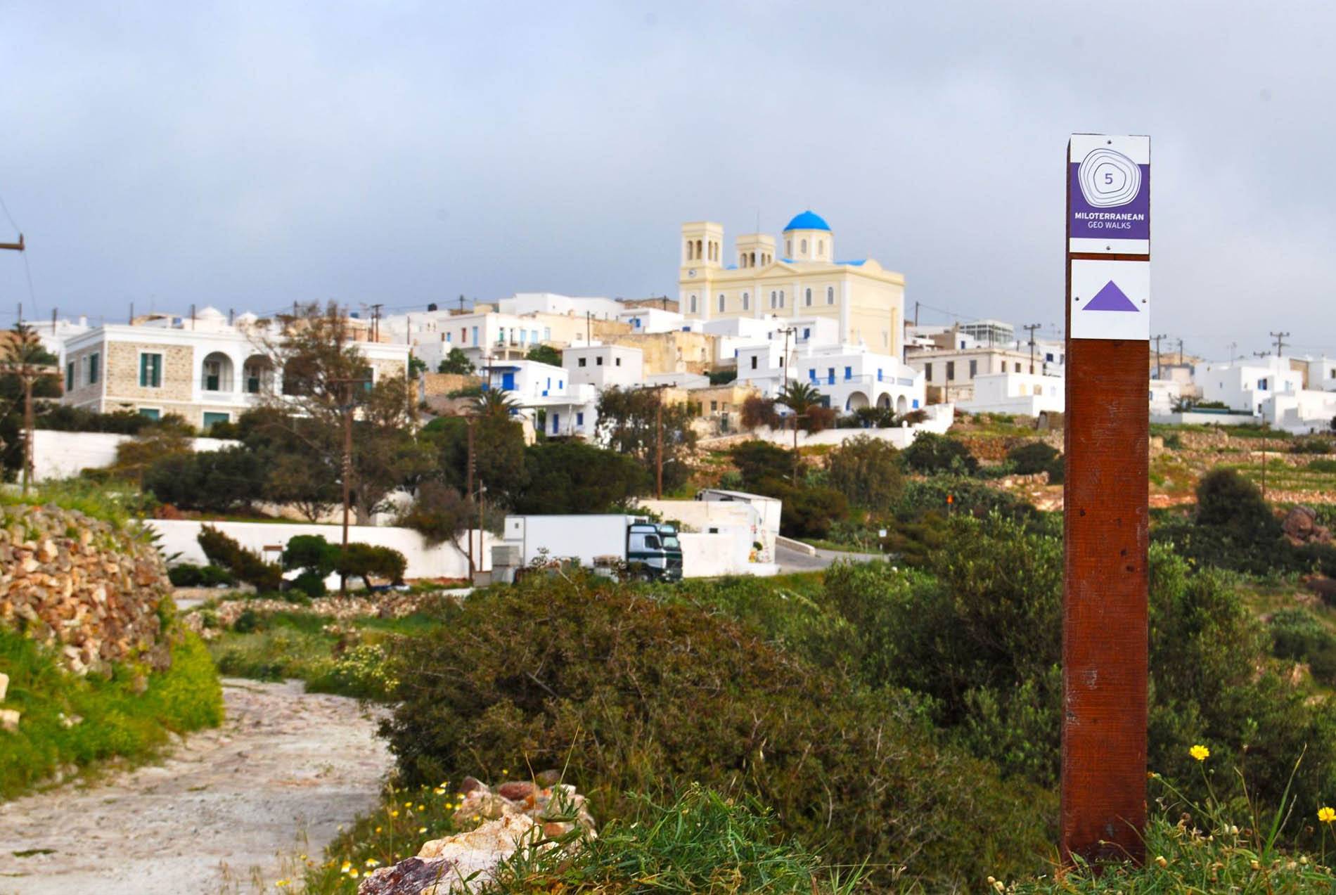 As soon as you come to the asphalt road, turn right, and after 100 m bear left on the little stone-paved road leading up to the center of Chorio (there are “Miloterranean” signposts at both intersections). Here, on your left, you will see the imposing “Afentakeio Nursing Home.”
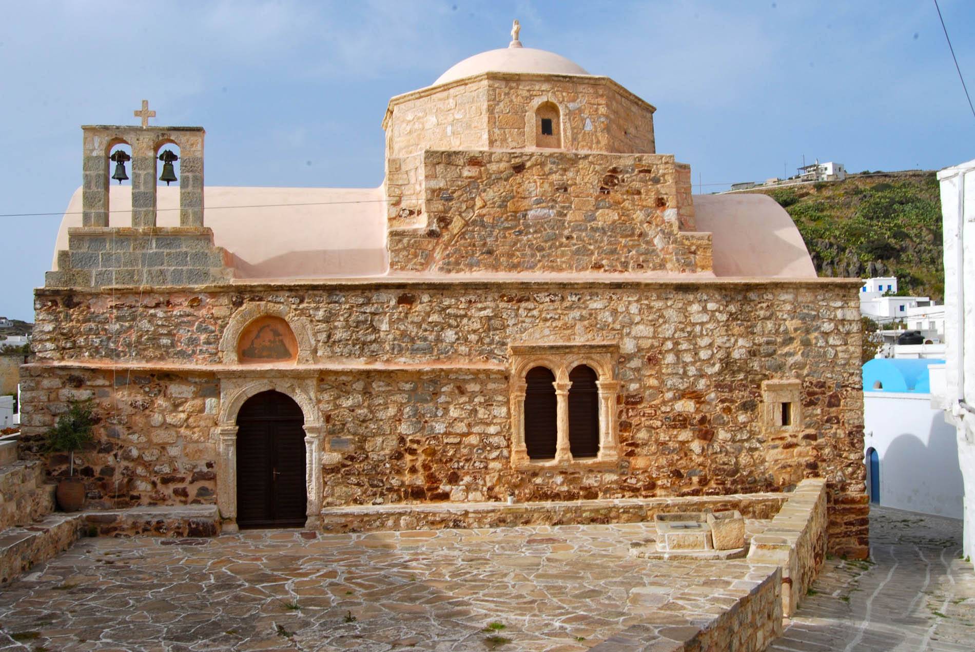
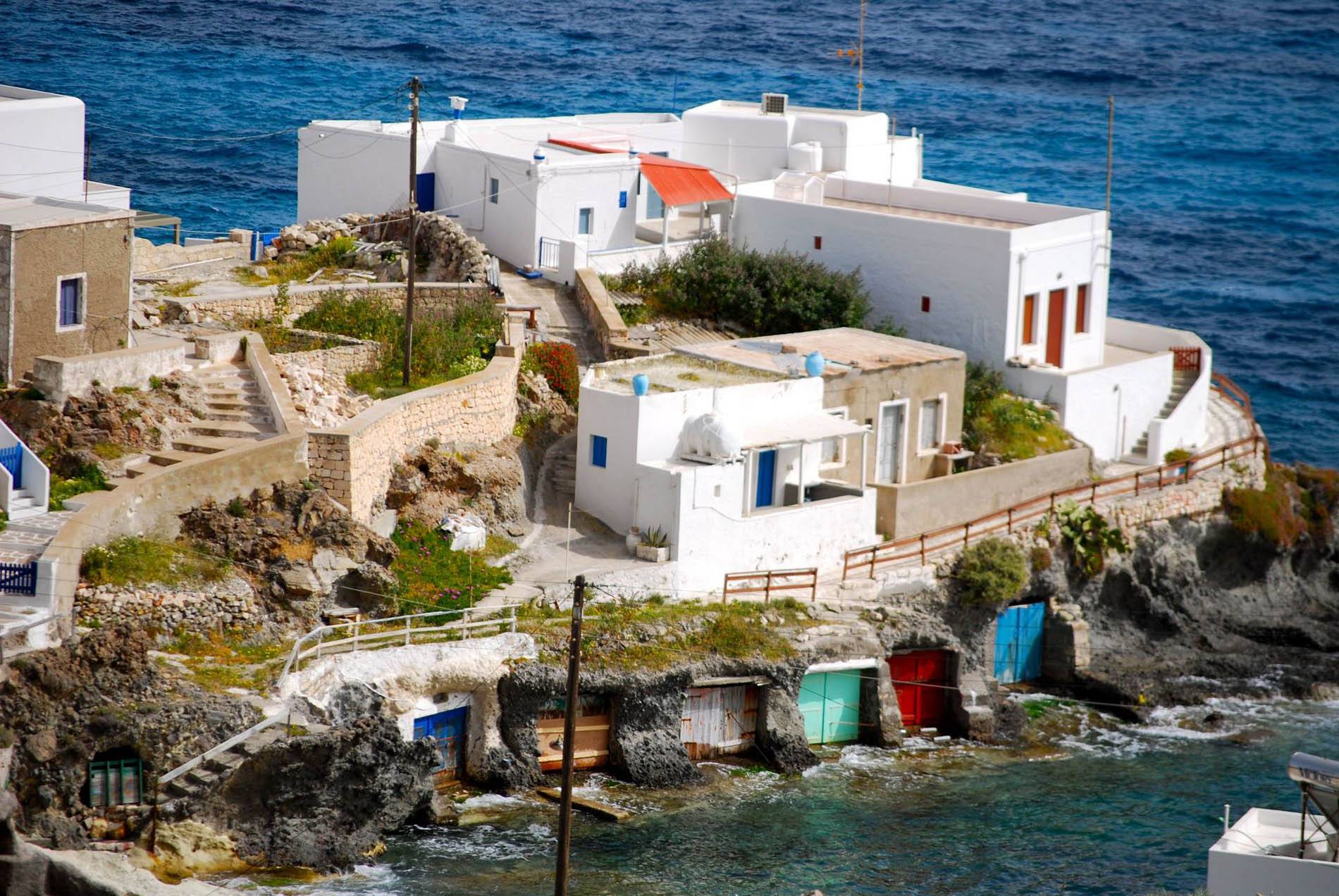
Inside Chorio there are dozens of cobblestone streets like a maze. Some are much frequented, others not. Whichever ones you take, you are sure to come across sights worth seeing, but we have laid out a certain “course” for you through the village, which will lead you to the most important attractions of the island’s main town. Following the “Miloterranean” signposts, the stone street will bring you to Panagia Odigitria (Our Lady the Guide) a few meters from the southeast corner of the Kastro (Greek word for castle). This is Kimolos’ cathedral, built in 1867-1874 on the site of an older church. The icon of Panagia Odigitria was brought here –according to tradition– from Sifnos, by Sifnians who came over to Kimolos in the 17th century.
Next to the church is the Kimolos Archaeological Museum, housed in a traditional two-storey house, one of the oldest in Chorio, which presents the history of the island from the time of its earliest inhabitants to the present day through an array of audio-visual materials. It is worth mentioning that there is a fine Folklore Museum inside the Kastro, organized by Dr. Christoulakis.
Next you come to the south gate or Kato Porta (“Lower Gate”) of the Kastro, the construction of which dates from the 14th-16th centuries. The date inscribed in the gate refers to repairs made after a pirate raid in 1638. Kastro is the main residential hub of old Chorio, the houses of which form with their external walls the wall of the castle. The material used to build the outer walls of these houses is hard hand-worked trachyte-andesite.
The southeast corner of the Kastro is taken up by the ruins of the Vafia house, once among the richest on the island. Continuing on your way on the cobblestone street around to the south side of the Kastro, where the main commercial street of Chorio used to be, called Agora by the townspeople, you arrive at its southwest corner, where you’ll see the church of Taxiarchis (Archangel) next to the Town Hall.
 Continuing around the outer western wall of the Kastro, you reach the north side and see the 17th century church of Aghios Ioannis Chrysostomos. Immediately beyond the church, the main square of Chorio awaits you, which the locals call the Kampos. The church of Aghios Spyridon is located here. From Kampos follow the main stone street to the northwest, where you’ll find many shops ideal for taking a break or to purchase necessaries, as there is a range of traditional cafes, a bakery, grocery stores and restaurants. Among the sights, don’t miss the church of Theologos, the church of Theoskepasti, and the well of Georgilas.
At the end of the cobblestone street is the OTE telecommunications building and the junction with the asphalt ring road coming up from the port. From here follow the main concrete road to the northern outskirts of Chorio, and after 250 m turn left at the junction, following the road that goes west (all intersections have “Miloterranean”signposts ).
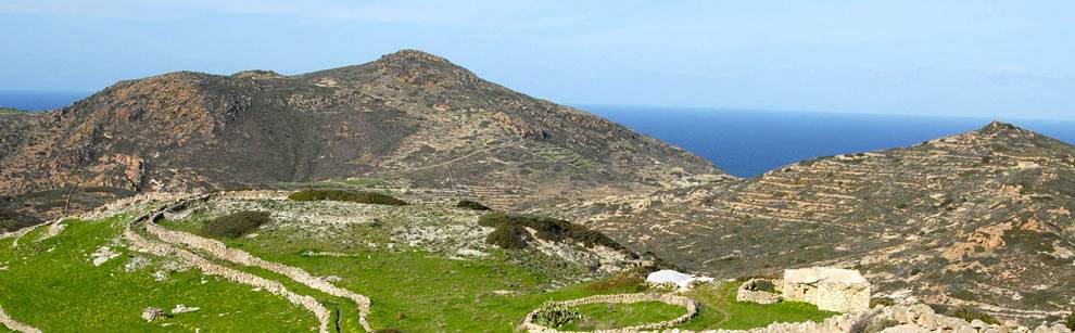
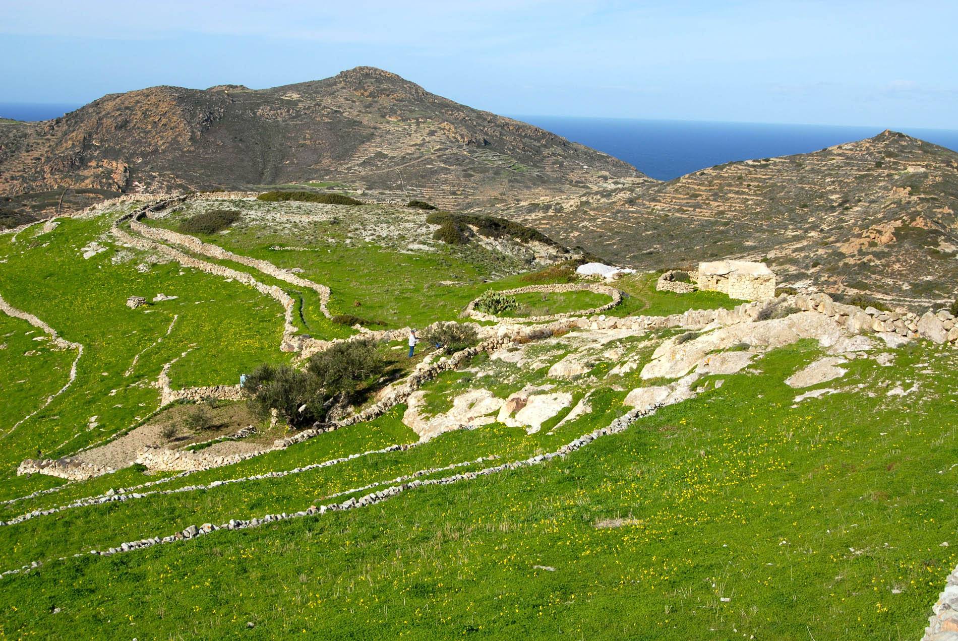
About 450 m from the intersection the cement road stops and turns into a passable dirt road that climbs Lembounia hill and offers magnificent views of the interior of the island. The people of Kimolos have planted olive groves and vineyards on the hill’s gentle slopes, and in the meadows below they have their plots, divided and moulded by terraced stone walls, where they cultivate cereals and summer vegetables. The windmills at the top of Chorio that were once used for grinding grain have fallen into disrepair, but their mechanisms –masterpieces of wood workers– are still visible. The road you are traveling on is frequently intersected by the old path, which in many places is paved with stones.
A few meters before the church of Aghii Anargyri (built in the 18th century), adjacent to the road (P1) you will see a sort of cistern, a large natural cavity in the rock which the locals have enlarged even more, where rainwater collects to form a small pool which provides drinking water to animals (sheep, goats, donkeys, horses, etc.). In this area, as well as just below on the right at the junction that leads to the chapel of Aghios Vasilios, you will see layers of ignimbrite, which has been extensively used as a building material for dry-stone walls, enclosures, farmhouses, etc. On the sides of the road you will see flows of welded pumice and volcanic glass fragments in varying degrees of alteration, in some places with pieces of rock in the lower layers (shale fragments, sediments, and lavas). Higher up on the slopes, there are well-defined welded tuffs from flows of volcanic ash.
The road climbs into a landscape where you increasingly meet with abandoned fields covered by the phrygana characteristic of Kimolos. At the top of the rise on your left stands the chapel of Prophitis Ilias, which was built in the mid-18th century. This area is dominated by the cultivation of olives, and you’ll see dozens of small olive trees and the innumerable stone terraces that protect the meager soil of the hills and allow the precious trees to put down roots.
 Approximately 900 m after the chapel of Aghii Anargyri you come to Seladi, where you will see a flat area on the left side of the road, and you can park your vehicle if you have chosen to do this route by car. At this point (there is a “Miloterranean” signpost) the path to Skiadi begins, a very relaxing and enjoyable walk along a good trail through beautiful scenery. The trail passes beside old plots with dry-stone walls (where Kimolians previously sowed grain) and olive groves, as well as the base of Kimolos’ second highest mountain, Sklavos. Ascending the slopes of Sklavos you will come across clumps of Phoenician juniper (Juniperus phoenicea), mastic trees (Pistacia lentiscus), spiny broom (Calicotome villosa), genista (Genista acanthoclada), Jerusalem sage (Phlomis fruticosa), lavender (Levandula stoechas) and Etruscan honeysuckle (Lonicera etrusca), which give another colour to the landscape. On the walls of the terraces, climbing plants like clematis (Clematis cirrhosa) and ephedra (Ephedra campylopoda) entangle their vines, while in many spots protected from the north wind many small vineyards with native species of grapes have a chance to grow. Along the trail, but generally in many places beside the dirt roads of the island, dozens of species of herbaceous and bulb plants flourish. But what dominates is Bermuda buttercup (Oxalis pes-caprae), a plant that arrived here in the early 20th century and is now prevalent all across Kimolos.
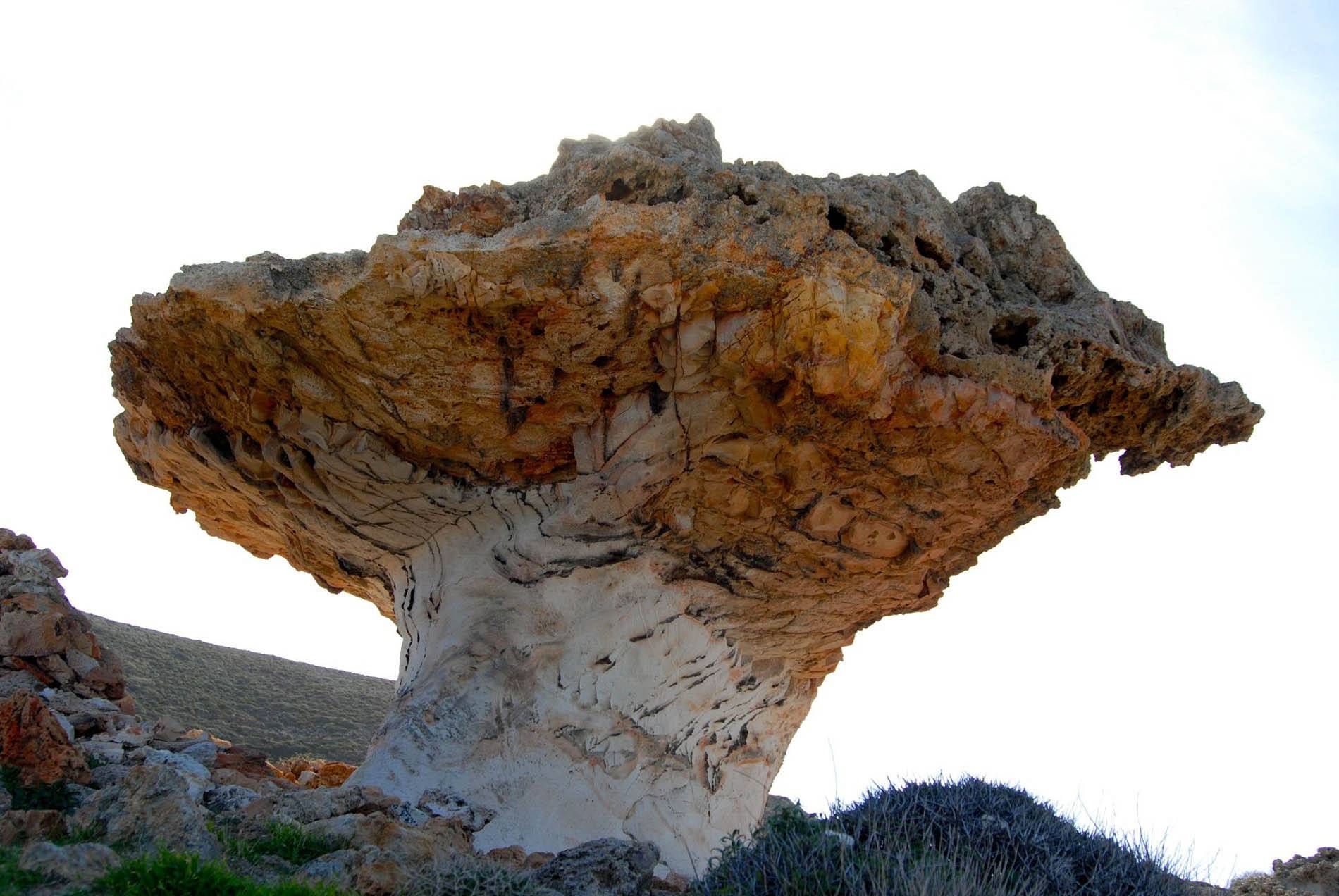 After a total distance of 1.5 km from the start of the trail, you will reach Skiadi (P2), a unique geological phenomenon of which the island’s inhabitants are very proud, and which stands out from afar, like a striking, rocky, volcanic umbrella. A “hat” of coarse brown porous ignimbrite “sits” on a “neck” of underlying fine white tuff. Lightly silicified pieces of the upper formation have allowed it to resist atmospheric erosion more than the underlying rock, resulting in the creation, over time, of this unusual “mushroom”. You can admire this work of art carved by nature, but it is advisable not to climb on it, both for reasons of your own safety and so as not to damage it.
In the rocks around Skiadi it is worth taking a closer look at the appearance of manganese oxides in the form of dendritic agglomerates in white tuff, as well as in the oxidation zones (Liesegang banding) around the cracks in the same formation. You will also notice unusual erosion surfaces, like fingerprints dipped in soft clay. In the wider surrounding area, atmospheric erosion (from rain and wind) has chiseled its signature on the rocks in formations of exceptional beauty.
Returning to the main road, retracing your steps on the same trail, you continue on the dirt road to the north/northeast. On your right, you’ll see the church of Mesa Prophitis Ilias, built in 1880, and on your left a second natural cistern. Next, an intersection with six roads awaits you.
If you go down the second road on your left (it is more a trail than a road), the one that heads to the northwest, after walking about 250 m you will reach “Fleaki” where you will see a small “fleitiko” well, as it is called on Kimolos (i.e. a well fed by a vein of underground water). If you continue hiking along the same path for another 800 m, you will reach the opposite slope and the old chapel of Panaghia Chymeli (or Birth of the Virgin), built in 1703.
It’s time now to go back to the intersection, continuing on the main road that goes to the southeast, following the “Miloterranean” signposts. On the surrounding hillsides, abandoned fields are carpeted by mastic (Pistacia lentiscus), wild olive (Olea europea var. silvestris) spiny broom (Calicotome villosa) heather (Erica manipuliflora), rock rose (Cistus creticus) prickly-branched centaur (Centaurea spinosa) and other phrygana plants. After about 2 km, you will reach a point (P3) that offers an “open-handed” view of the mountain slopes of Korakies on your left, where there are old galleries for mining manganese. The extraction of manganese here, as also in the Kokina area, took place from 1896 to 1910, with gallery tunnels that tapped into the veins of manganese minerals in silicified volcanic formations, often with the presence of barite as well. The ore was loaded onto wagons and transported by rail to the small port of Aghios Minas, where it was loaded onto boats, and where even today there are remains of the stock of ore ready for loading.
Manganese mining on Kimolos took place in the broader context of mining concessions given by the Greek state during this period throughout the country and particularly on the islands. The exploitation of manganese at Vani on Milos (by the Serpieri company) and on Kimolos (by the Cyclades company) came to an end in the face of competition from deposits with higher manganese content in the Caucasus.
On your right, toward Ksaplovouni, you can see a perlite mining operation in the distance. About 600 m further on, you will come to a place on the road (P4) where you have a view on your left, to the north, to old mining galleries in the Siderokapsia area (supposed by some to be ancient mines for silver-bearing ore) and to the active bentonite mine, in the area of Prasa. In the lateral extensions of the deposit of bentonite a natural greenish mixture of bentonite-zeolite (mordenite) has also been found. The hard volcanic breccia overlying the ore has found applications as pozzolanic additives in the cement industry. Considering the workers in this mine and the residents of Kimolos working on a daily basis at S&B Industrial Minerals S.A. on Milos, a notable percentage of the active population (estimated at around 10%, i.e. about 40 employees) is employed in the mining industry, which is a traditional occupation on Kimolos.
In the area of Prasa, on the coast, there is a hot spring operating during the summer as a hydrotherapy spa.
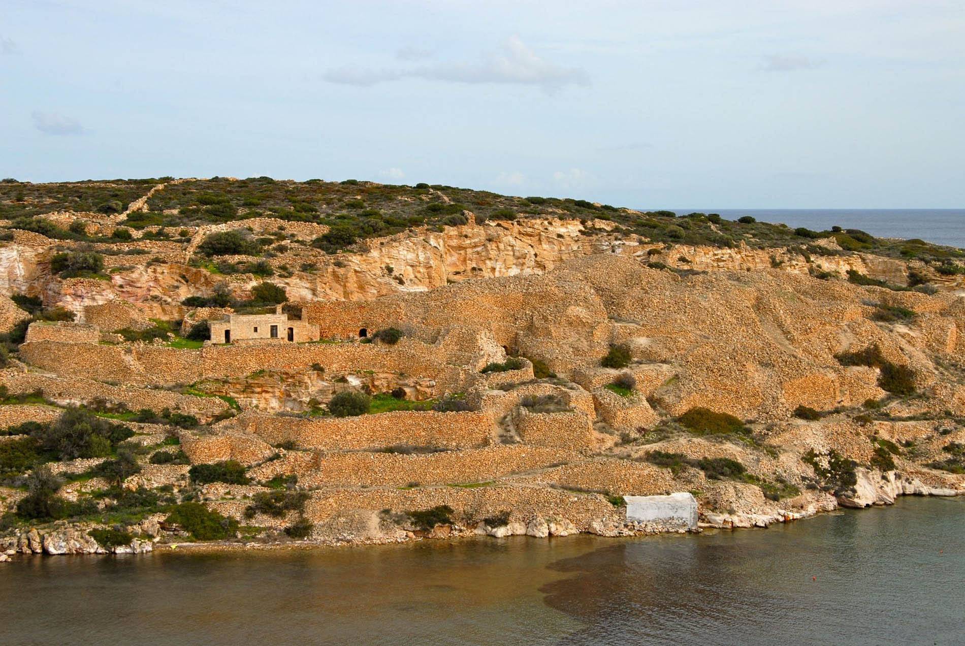 Going a little further on the main dirt road, you reach the coast, in the area of the port and small village of Aghios Minas (P5), which took its name from the church of the same name. The church was built in 1887, replacing an older one built on the eastern arm of the cove to which reference is made in a source from 1771. The buildings and accumulations of stones you see across on the eastern arm of the cove are a large outdoor workshop for dressing tufa, the rock that for ages has been used on Kimolos in the construction of buildings of all kinds. Because of its relatively low specific gravity, its relative ease of extraction, shaping and working, and its durability, this type of rock has been used extensively as a building material and was the main export of the island for many years. These building stones with their reddish-white speckles arrived on boats in Attica, where even today one can see them (the size of cinder-blocks) in many old yard walls in Piraeus and the western suburbs of Athens.
 From Aghios Minas, the paved road hugs the coast, where you can see old “syrmata” (rock-cut structures near the shore where the islanders’ boats could be hauled out and stored in case of foul weather) in the area of Goupa-Kara. The road takes you back to Chorio and from there to the port of Psathi, where visitors can catch the boat back to Milos.
View the map.