View the map.
This route has a total length of about 5 km (for the main part) and can be done either by car or on foot. Three small secondary routes (with a total length of 1.5 km) are suggested along the way. If you choose to hike, it will take you about 6 hours (not counting the return trip). If you go by car, you will still need to walk along footpaths at some points.
Starting out from the port of Adamas, you head north along the main road to Plaka. Αt 400 m, where you see the Miloterranean signpost, take a 90° left turn. About 200 m further on, turn right and go uphill on the cement road. At first, you pass by farmland mainly planted with olive trees. As you go up the hill the landscape changes and the typical phrygana vegetation of the island appears. You will see mastic (Pistacia lentiscus), genista (Genista acanthoclada), prickly burnet (Sarcopoterium spinosum), Jerusalem sage (Phlomis fruticosa), coastal germander (Teucrium brevifolium), but also aromatic herbs such as thyme (Thymus capitatus), savory (Satureja thymbra), lavender (Lavandula stoechas), and Greek sage (Salvia triloba). During the rainy season everything is green. Dozens of species of herbaceous plants emerge among the phrygana, the most visible and recognizable being asphodel (Asphodelus microcarpus) and sea onion (Urginea maritima). In the middle of spring a burst of scents and colors floods over Milos in preparation for the summer, when all plants, with few exceptions, fall into a sleep that helps them survive the long, dry, hot Mediterranean summer. The rocks you see in this area are volcanic tuffs in shades of white and gray. Strata with pieces of pumice welded with a glassy pumice binder predominate, alternating with layers of fine volcanic ash and sand. The age of the tuffs goes back to the Upper Pliocene.
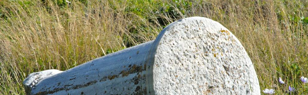
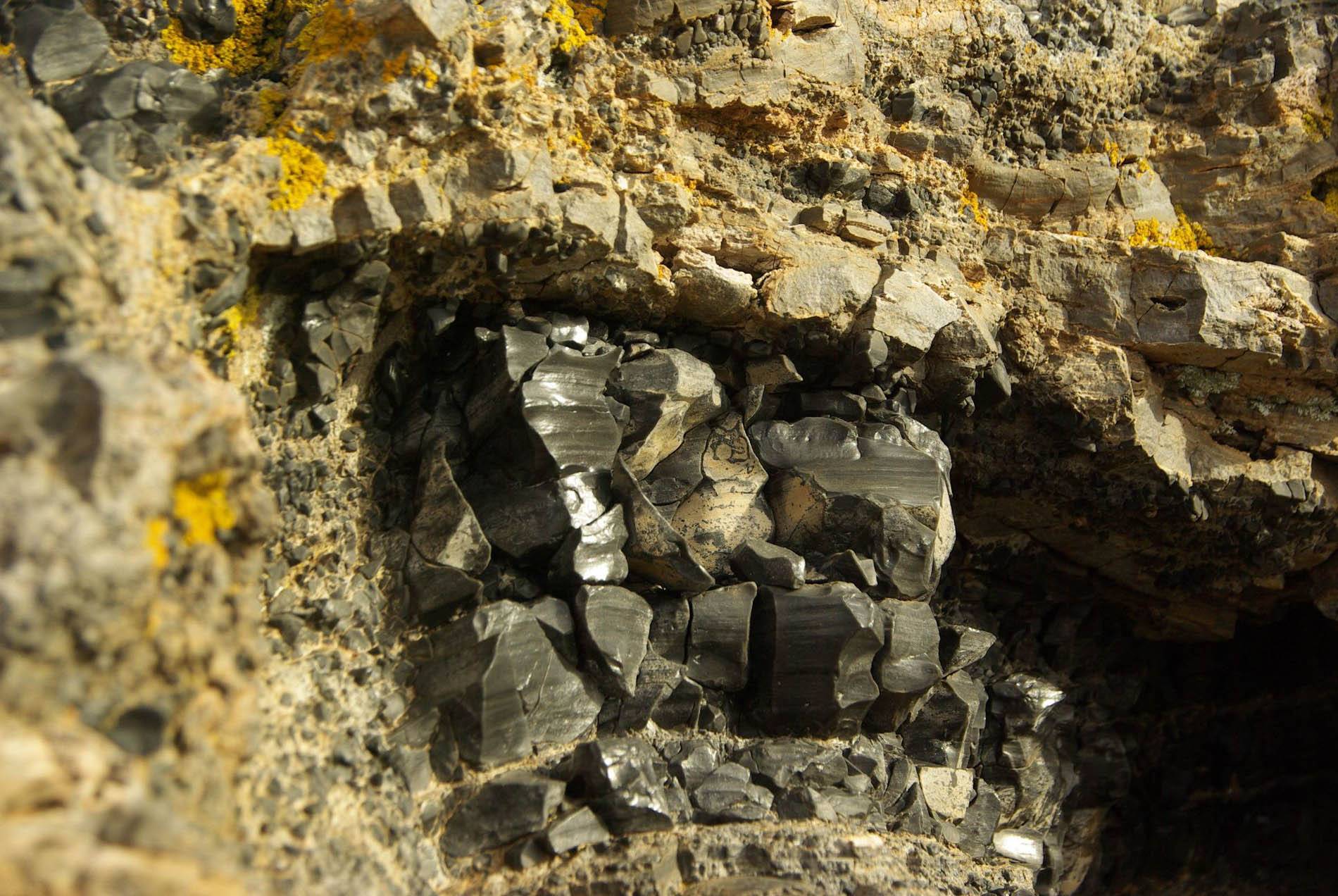 About 1.2 km past the last junction at the top of the uphill, turn left on a narrow dirt road. This is the first of the 3 suggested secondary routes. After about 100 m you can leave your car in the flat area and continue to the south, walking for another 150 m across the small plateau where fallow fields formerly grew wheat and barley. This whole area from the top of the plateau to the lower southern slopes of the hill, called Nychia, is one of the two prehistoric obsidian quarries on Milos (P1). The deposits of obsidian, the black, glassy rock characteristic of Milos, are easily accessible from the sea. The first sailors in the Aegean must have found obsidian here at the end of the Palaeolithic era and must have taken it for the first time to the Argolid peninsula and other areas of the Aegean. The fishermen of the Mesolithic era and farmers of the 7th millennium BC must have arrived here seeking obsidian, the stone with “conchoidal” fracture which, with proper shaping, produces weapons and tools with sharp edges (knives, arrow points, spears, scrapers, axes, sickles, razors, etc.).
Rock wastes from the mining and working of obsidian at Nychia cover an area of approximately 90 hectares. At some points, the density of natural nodules and stone chips is impressive. It is estimated that approx. 5 million cores were worked at Nychia, although it is impossible to calculate with precision the productivity of the quarry over the 8,000 years it is estimated to have been in operation.
Removal of obsidian from the parent rock was easier here than it was in Demenagaki (see Route 3 – Sulfur Mines) on the eastern side of the island, and for that reason obsidian exploitation at Nychia was more systematic. Small mining pits and trenches have been found in various places. The quarrying of obsidian from the hard bedrock yielded excellent “nodules” and “cores”, which were then carried by early means of sea transport across the Aegean and to mainland Greece.
Therefore, only the first stage in processing (the production of nodules) took place on Milos and not the making of the finished product (a sharp object), which could be damaged during transport by sea. From nodules or blocks of rock, the various prehistoric obsidian workshops in the Aegean manufactured a wide variety of tools and weapons. The name “Nychia” (“nails”) is due precisely to these waste heaps from the prehistoric quarrying of obsidian, which resemble fingernails.
At Nychia, besides obsidian, there are also appearances of rhyolites with laminar flow along with “landforms” (notches) in various shapes, which are created by sea winds eroding the volcanic rocks.
After returning to where you left your vehicle, continue on the main route towards Trypiti. You will pass abandoned fields, but you will also see quite a few still being cultivated, mainly for wheat and barley, but also for summer gardening, mostly with drought-tolerant plants, i.e. those that can live on the moisture present in the ground. The rocks from Nychia to Trypiti are tuffs formed from older pyroclastic materials altered in a marine environment, as evidenced by the presence of marine fossils (mainly molluscs and echinoids). These tuffs display an almost horizontal stratification and are at variance with the older volcanic rocks. Most are fine-grained, with pieces of rhyolite and fragments of obsidian.
Continuing north/northwest to Trypiti, you will pass the junction for Schinopi on your left, and 250 m further you will see on your left side a little chapel dedicated to the memory of two saints, Saints Antonios and Eleftherios (P2). It was built in 1899 by a man from Milos whose two sons, Antonis and Lefteris, were serving in the army during the Greco-Turkish War of 1897. Their father, praying for their safe return, promised to build a church to the memory of the saints for protecting his sons in the war.
Approx. 350 m further on, on the left you will see the intersection for Klimatovouni. It is worthwhile taking this second secondary route, passing through the picturesque village and following the narrow concrete road to the west to its end (a distance of 500 m) to visit the old church of Panagia Tourliani (P3), a wonderful “balcony” with great views of western Milos, Adamas Bay, and Antimilos. Especially at sunset, the view will enchant you. After returning to the main road, continue north/northwest until you arrive at Trypiti.
Trypiti is a quaint village on the SW slope of the Hill of Mills, which took its name from the many windmills operating in the area in the past. The name Trypiti (“full of holes”), in its turn, probably came from the fact that the village was built over the Early Christian cemetery (the catacombs) of the region, carved, like many other rock-cut structures on the island, in the soft volcanic tuff. In the first half of the 19th century, the first inhabitants built their homes just a few dozen meters from the walls of the ancient city of Milos, which lay in the area, using materials from the walls and from other ancient buildings. The residents of Trypiti are known for the variety of professions they have at times resorted to because of the infertile land in the area. Many have turned to the mines which have flourished on Milos (the Sulfur Mines at Paliorema, the manganese mine at Vani, and later the kaolin mines and mines for industrial minerals) and have moved to other mining areas in Greece and mostly abroad, when in the early 20th century the mining industry experienced an economic crisis.
The large parish church of Trypiti is dedicated to St. Nicholas or Aghios Nikolaos (P4). Right past Aghios Nikolaos, in about 50 m, hikers may choose to follow the little road to the left and reach the chapel of Panagia Faneromeni (P5). By car, follow the motorway and, at the intersection, at the north edge of Trypiti, bear left on the road that goes down to the catacombs and the archaeological site of ancient Milos. 300 m past the intersection you will see the beautiful chapel of Panagia Faneromeni (P5). Like many churches on Milos, it too is private. Preserved in the sanctuary are fragments of a fresco of the Nikopoios (“Victory bringing”) Virgin, probably from the 15th century, while in the north wall may be seen the arcosolia tombs (carved funerary niches) of unknown date.
The downhill cement road stops after 700 m at a parking area, from which you continue on foot to go to the catacombs (P6) and the archaeological site of ancient Milos surrounded by centuries-old olive trees. In the ravine east of Klima you will see towering cypresses (Cupressus sempervirens), probably remnants from the original native cypress forest.
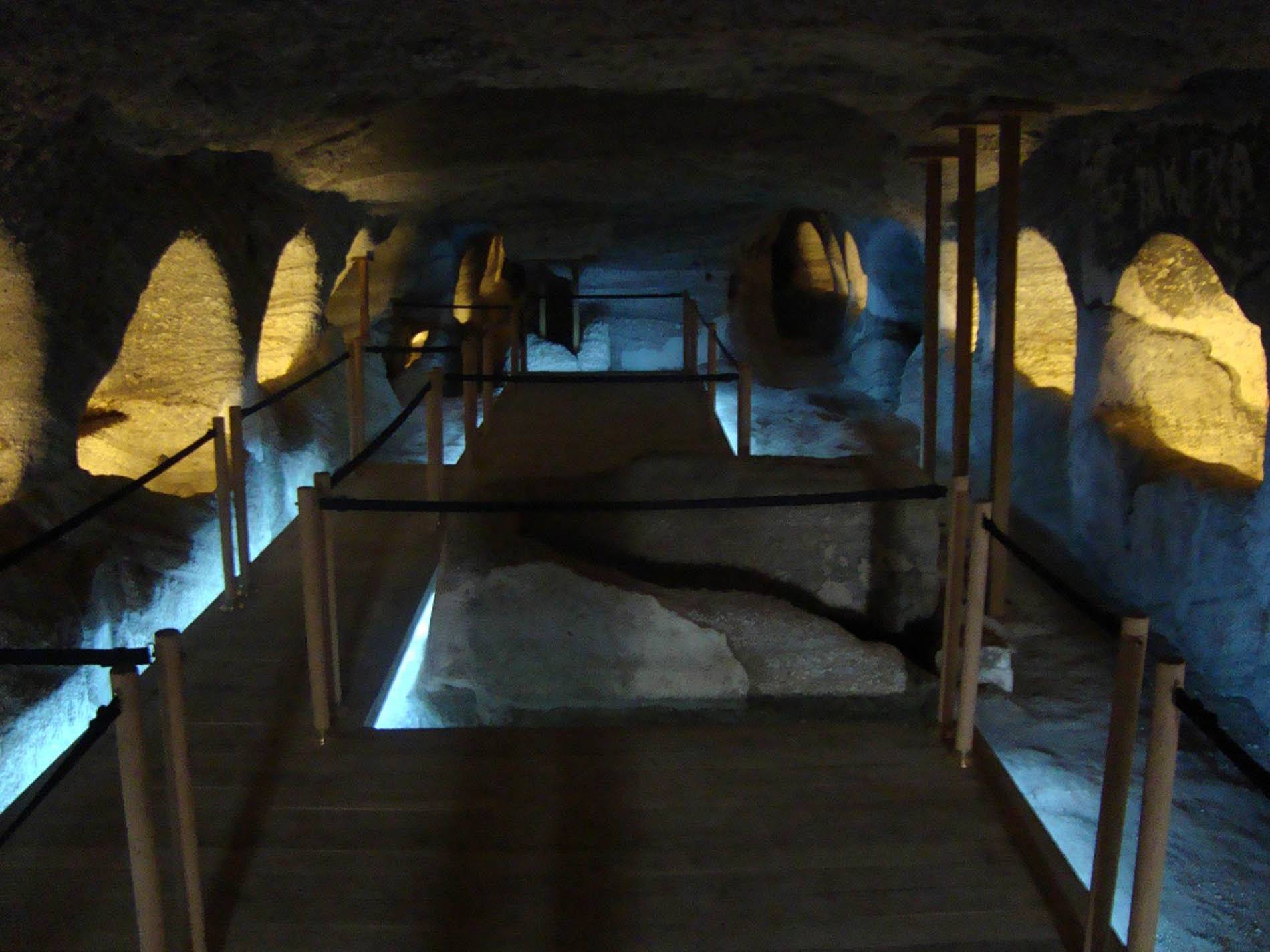 The Catacombs of Milos is an early Christian monument (2nd-5th c. AD), evidence of the presence of the first Christians on Milos, who were –as indicated by inscriptions– Jews engaged in marketing the island’s minerals, which were exported to every corner of the Roman Empire. The etymology of the word catacomb, from the ancient Greek words kata + kymvi (referring to a hollow, open vessel), refers to the underground nature and form of these rock-carved tombs. Under Roman law, cemeteries were strictly recognized as sanctuaries. The first Christians thus took advantage of the inviolability of the catacombs, in order to use them not only for funerary monuments but as places of worship and assembly.
The Catacombs of Milos consist of three carved chambers independent of each other, but joined later with six cavernous “hallways”. The tombs are carved in the sides (arcosolia) and the floor of the main chambers, reaching a total number of 291. After the deceased was placed inside, each opening was sealed with tuff or a marble slab. When the catacombs were discovered, in 1840, they had already for the most part been plundered by looters, pirates and ignorant or malicious “visitors”, but much of the damage was due to the perishable nature of the soft, volcanic tuff, that is, of the natural rock out of which the tombs had been carved. At various places decorations, inscriptions, early Christian symbols and monograms have been identified, all relating to the dead who had at various times been buried there. The catacombs originally belonged to a private individual, who in 1882 transferred them to the Greek state. Because of the catacombs, Milos has been designated as a ‘’Holy Island’’, while the Holy Synod decreed the Sunday of All Saints the feast day of the catacombs. The second catacomb may be visited today with a nominal admission fee.
You leave the Catacombs parking area and in 100 m you turn left onto a passable dirt road, following the signposts to the archaeological site. A few meters further on you will see the sign that marks the spot where the famous statue of the Venus de Milo (Aphrodite of Milos) was found in 1820 (when Greece was still under Turkish rule) by a villager doing farm work, in at least six pieces, among other ancient fragments. The piece of the statue consisting of the left hand holding an apple as well as the base with an inscription must have been among these pieces, though they are now among the missing, because, although their finding was recorded, they were not initially assigned to the statue and later disappeared without having been sought after in order to be reconnected to it.
This semi-nude female figure of a height of 2 m, sculpted in the first century BC in Parian marble, is most likely Aphrodite, although this identification has not been established with absolute certainty. The statue is a Hellenistic copy of a classical original, which, due to its style, was originally attributed to Praxiteles, but the actual sculptor was Alexander or Agisandros from Antioch, as evidenced by the inscription on the lost base. The positions that the figure’s hands may have had have been the subject of many theories and studies. The statue is now in the Louvre in Paris, as the French naval officers who happened to be on the island at the time of its discovery immediately grasped its archaeological and artistic value and encouraged French diplomats to express an interest in it, who, after an intense effort, managed to obtain it, overcoming the objections of the island authorities. There is now a plaster copy of the original in the Milos Archaeological Museum.
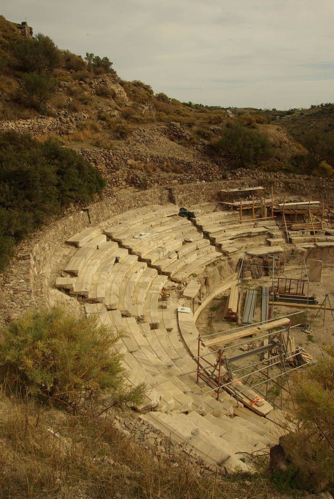 The dirt road ends 400 m further on in front of the ancient theater of Milos (P7). It was first excavated in 1816-7 by the German architect Haller von Hallerstein, who had special permission from the Turkish authorities to conduct archaeological investigations in the Peloponnese and the islands, although its existence had been attested to by historical sources much earlier. What you see today is the orchestra area down to floor level, 7 tiers with 6 rows of seats in the cavea (the space for the audience) and architectural features, especially from the stage, of superb aesthetics and artistry. In the theatre that survives today there is room for about 700 audience members, while its original capacity is estimated at 7,000. The theater must have been built in the Hellenistic period (3rd century BC) –as recent excavations have shown– and was in use until the Roman period (1st century AD). The tiers of seats and the decoration are of marble, a material that does not exist on the volcanic island of Milos and which has therefore been imported and taken as evidence of the prosperity of the island during this period.
Above the ancient theater, at “Treis Ekklisies” (Three Churches) have been found remains of a Christian baptistery belonging to a large basilica dedicated to Christ. The square font is surrounded on all sides by two bench-like steps in the form of a cross, each with a semicircular niche at the top level. The baptistery would have been faced inside and out with white marble.
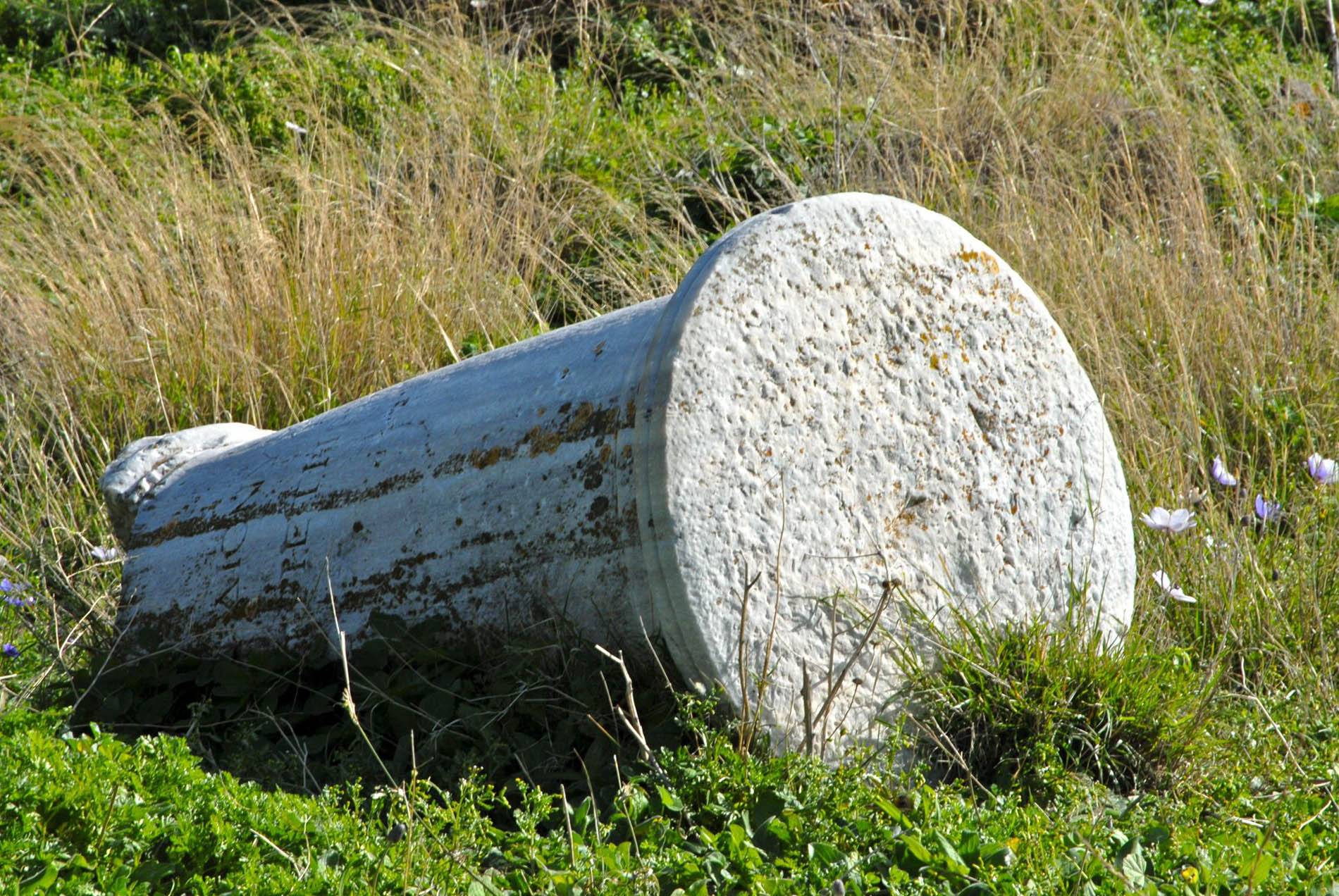 You now leave the theater by returning on the dirt road, and at a flat area on your left, about 100 m before coming to the main road to the catacombs, you leave your car and follow the Miloterranean signposts to visit the place where ancient Milos was located. This marked trail is the third suggested secondary route, heading down to the area called Tramithia and ending on the coast. Your walk is all inside the archaeological site, and in many places you will pass by ancient walls, ruins of ancient buildings and architectural elements scattered among age-old olive trees and huge mastic trees (Pistacia lentiscus). This is the ancient city of Milos of the Classical and Hellenistic periods, when social and economic activity was concentrated on the north part of the eastern half of the island, between two hills (Profitis Ilias and Pyrgiante). The city grew up around the center of public life (the market, temple, parliament) with its dwellings and walls. The walls enclosed both hills and sloped down to the sea, but the ancient port at Klima (where there are remains of an ancient pier) was located outside the walls. The cemetery was also located outside the walls on the east side of the city, and the tombs were spacious carved chambers with stepped entryways. The ancient walls, the building foundations, and the stonework of the ancient theater were constructed of andesite from Milos. In many cases, however, such as columns, decorative surfaces, etc., marble was used. The Romans also used granite. It is assumed that the polishing of marble elements was done with local pumice. Αbout 180 m from the flat area, you’ll be at a spot where the dirt path forks. Taking the path to your left, make another small detour of 150 m –as part of the third secondary route– to climb up to the chapel of Profitis Ilias (P8) that crowns the hill, built with the remains of an ancient temple of which various pieces have been incorporated into the walls or scattered about. During World War I, the French installed coastal and antiaircraft artillery in the hill, and the cells of the church housed the operators of the battery (See Gr. Belivanakis, “The Anglo-French on Milos during the First World War”’, Athens 2003). The views over the surrounding area are stunning. Going back once again, the marked trail heads downhill ending on the coast, near the chapel of Aghios Nikolaos (P9), which is much older than the first reference made to it in legal documents (1871) but was renovated during the decade 1950-1960. That completes the route and you can return to where you left your vehicle.
View the map.